[ Whereis® API Home ] [ JSON API Home ] [ Services ] [ Map Services ]
Use this service to obtain a static map when you know what markers or other artefacts you need to display. Returns a map in one of three formats (see Map Services), based on <mapData>.
The map service calculates the bounds and zoom level as a best-fit to accommodate the request.
URL
HTTP Post to <ENDPOINT>/service/map
Request format
{
"height":<int>,
"width":<int>,
"layers": ["STREET", "PHOTO", "HYBRID"]
"mapData":[<mapData>]
}
Rules
Parameter | Mandatory? | Description |
height | Y | Image height in pixels. Min = 1, max = 1600 |
width | Y | Image width in pixels. Min = 1, Max = 1600 |
layers | N | Array containing one or more of: "STREET" = conventional map "PHOTO" = aerial view "HYBRID" = semi-transparent layer with street names and labels |
<mapData> | Y | A list of <mapData> arrays, which may include markers, routes, and other geometry |
Examples
Ellipse
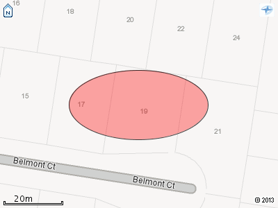
Sample request
{
  "height":"300",
  "width":"400",
  "layers": ["STREET"],
  "mapData":[{
    "type":"ellipse",
    "values":
       [{"centre":
             {"lon":145.159665,"lat":-37.959788},
          "radiusX":100,
          "radiusY":50
         }]
    }]
}
Sample response
Polyline
Sample request
{
    "layers":["PHOTO","HYBRID"],
    "height":"1200",
    "width":"1600",
    "mapData":[
        {"values":[
            {"points":[
                {"lat":-37.81563,"lon":144.95817},
                {"lat":-37.81561,"lon":144.95825},
                {"lat":-37.81571,"lon":144.9583},
                {"lat":-37.81627,"lon":144.95856},
                {"lat":-37.81646,"lon":144.95865},
                {"lat":-37.81665,"lon":144.95872},
                {"lat":-37.81722,"lon":144.95901},
                {"lat":-37.81737,"lon":144.95909},
                {"lat":-37.81753,"lon":144.95917}
        ]}],
        "type":"polyline",
        "style":{
            "fillColour":"#380EB5",
            "strokeColour":"#000080",
            "strokeWidth":"10",
            "fillOpacity":"0.3",
            "strokeOpacity":"1.0"}}
        ]
}
Sample response
Multiple layers may be requested, but if they are opaque only the top layer (the last in the list) will be visible.